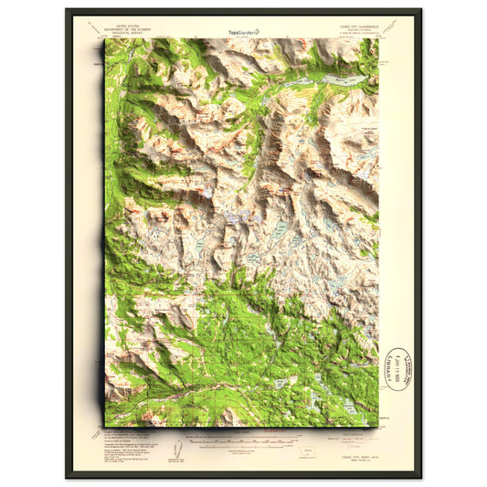
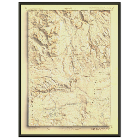
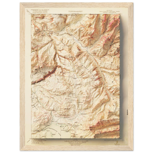
Collection: Historic USGS Relief Maps
This collection is based on historic USGS topographic maps, enhanced with modern hill shading and careful color correction to improve depth and readability.
The result preserves the original character of the maps while revealing terrain in a way that was not possible when they were first produced.
Original publication dates for these maps range from late 1800s to early 2000s. Map areas range from 7.5x7.5 minute (small area) to 1x2 degrees (larger area). Some of the modernized historic maps showcase entire states and countries!
-
Original USGS map sources
-
Added relief shading for a three-dimensional effect
-
Color corrected for improved contrast and legibility

-
1958 Bozeman, MT | 1x2 Degree Shaded Historic USGS Map
Regular price From $49.00 USDRegular priceUnit price per$0.00 USDSale price From $49.00 USD -
1989 Ennis, MT | 30'x60' Shaded Historic USGS Map
Regular price From $49.00 USDRegular priceUnit price per$0.00 USDSale price From $49.00 USD -
1981 Hungry Horse, MT | 30'x60' Shaded Historic USGS Map
Regular price From $49.00 USDRegular priceUnit price per$0.00 USDSale price From $49.00 USD -
1993 Scapegoat Wilderness / Dearborn River, MT | 30'x60' Shaded Historic USGS Map
Regular price From $49.00 USDRegular priceUnit price per$0.00 USDSale price From $49.00 USD -
1988 Hyalite Canyon, MT | 7.5'x7.5' Shaded Historic USGS Map
Regular price From $49.00 USDRegular priceUnit price per$0.00 USDSale price From $49.00 USD -
1914 Nyack | Jewel Basin, Flathead Alps & Glacier National Park, MT | 30'x30' Shaded Historic USGS Map
Regular price From $49.00 USDRegular priceUnit price per$0.00 USDSale price From $49.00 USD -
1959 Yellowstone National Park | Tower Junction | 15'x15' Shaded Historic USGS Map
Regular price From $49.00 USDRegular priceUnit price per$0.00 USDSale price From $49.00 USD -
1959 Cooke City, MT | 15'x15' Shaded Historic USGS Map
Regular price From $49.00 USDRegular priceUnit price per$0.00 USDSale price From $49.00 USD -
1983 Northern Yellowstone National Park | 30'x60' Shaded Historic USGS Map
Regular price From $49.00 USDRegular priceUnit price per$0.00 USDSale price From $49.00 USD -
1982 Southern Yellowstone National Park | 30'x60' Shaded Historic USGS Map
Regular price From $49.00 USDRegular priceUnit price per$0.00 USDSale price From $49.00 USD -
1981 Whitefish Range, MT | 30'x60' Shaded Historic USGS Map
Regular price From $49.00 USDRegular priceUnit price per$0.00 USDSale price From $49.00 USD -
1979 Mt. Baker, WA | 30'x60' Shaded Historic USGS Map
Regular price From $49.00 USDRegular priceUnit price per$0.00 USDSale price From $49.00 USD -
2001 City of Rocks National Reserve, ID | 7.5'x7.5' Historic USGS Map
Regular price From $49.00 USDRegular priceUnit price per$0.00 USDSale price From $49.00 USD -
1927 Mount Rainier, WA | 30'x30' Shaded Historic USGS Map
Regular price From $49.00 USDRegular priceUnit price per$0.00 USDSale price From $49.00 USD -
1896 Yellowstone National Park | Gallatin / NW Yellowstone | 30'x30' Shaded Historic USGS Map
Regular price From $49.00 USDRegular priceUnit price per$0.00 USDSale price From $49.00 USD -
1911 Yellowstone National Park, WY | Canyon | 30'x30' Shaded Historic USGS Map
Regular price From $49.00 USDRegular priceUnit price per$0.00 USDSale price From $49.00 USD -
1911 Yellowstone National Park | Gallatin / NW Yellowstone | 30'x30' Shaded Historic USGS Map
Regular price From $49.00 USDRegular priceUnit price per$0.00 USDSale price From $49.00 USD -
1989 Red Lodge & Beartooth Mountains, MT | 30'x60' Shaded Historic USGS Map
Regular price From $49.00 USDRegular priceUnit price per$0.00 USDSale price From $49.00 USD -
1993 Hebgen Lake / West Yellowstone, MT | 30'x60' Shaded Historic USGS Map
Regular price From $49.00 USDRegular priceUnit price per$0.00 USDSale price From $49.00 USD -
1992 Gardiner, MT | 30'x60' Shaded Historic USGS Map
Regular price From $49.00 USDRegular priceUnit price per$0.00 USDSale price From $49.00 USD -
1951, Bridger Mountains and Sedan, MT | 15'x15' Shaded Historic USGS Map
Regular price From $49.00 USDRegular priceUnit price per$0.00 USDSale price From $49.00 USD -
1952 Bozeman, MT | 15'x15' Shaded Historic USGS Map
Regular price From $49.00 USDRegular priceUnit price per$0.00 USDSale price From $49.00 USD -
1950 Big Sky, MT | 15'x15' Shaded Historic USGS Map
Regular price From $49.00 USDRegular priceUnit price per$0.00 USDSale price From $49.00 USD -
1987 Saddle Peak, MT | 7.5'x7.5' Shaded Historic USGS Map
Regular price From $49.00 USDRegular priceUnit price per$0.00 USDSale price From $49.00 USD


More Map Collections
-

Recreational Topographic Maps
This collection includes topographic and terrain-based maps of outdoor recreation areas across...
-

Hydrology & Watershed Maps
These maps focus on river systems, drainage networks, and watershed boundaries, built...
-

Antique & Old Maps
This collection features historical and antique maps that have been carefully restored...
-

Historic USGS Relief Maps
This collection is based on historic USGS topographic maps, enhanced with modern...


